Voices In The Landscape
What are the new access opportunities that the Project will be delivering?
Why is this limb of the Project called Voices in the Landscape?
The most significant human intervention in and reshaping of this landscape and the lives of the people who lived in it came as a result of the Second World War and what followed in its immediate aftermath. In 1940 the UK Government created 2 military bases, RAF Bodorgan and the Ty Croes Camp. From 1949 the UK Government sponsored the creation of the Llanfeirian Experimental Farm. These interventions by the central UK Government had a huge and lasting impact.
Why is the Project delivering new access opportunities?
The seed: talking to the generation present in the 1940s led to a growing awareness of the scale of the impact of the Second World War on the people and landscape of this part of Anglesey.
We wanted to tell this story of:
- The lives of extraordinary people: personified by Twm Roberts, sacked from the Bodorgan Gardens after a contrived fight with the Head Gardner so he could join RAF at the new RAF Bodorgan the very next day; who went on to serve as a bomb defuser; then a miner in South Wales; and who returned to Anglesey in his later years to take up gardening again.
- A landscape damaged by war: one member of the older generation can remember playing in piles of sand bull-dozed to make the runways of RAF Bodorgan and who speaks of how silent the fields are today.
- Utopia on Anglesey: the Llanfeirian Farm Experiment is such an unusual and interesting but unknown story with echoes of George Orwell’s contemporaneous ‘Animal Farm’.
- Landscape change over time: the Bodorgan Estate’s archives are a unique resource which document environmental and landscape change from the 1720s.
Tell us about the new footpath routes
We will be providing 3 new sections of footpath to walk all of which connect with the existing public rights of way network.
These new footpaths cater for a range of walking abilities.
New footpath section 1: Short, circular route at Llangadwaladr (‘Cadwaladr’)
This is an easy circular route to and from Llangadwaladr Church to the new landform that we intend to create. The top of the new landform will provide sweeping views across Anglesey from Llyn Coron to the sea. Also visible will be one of the grass runways of the former RAF Bodorgan which we intend to bring back to life with wildflower planting.
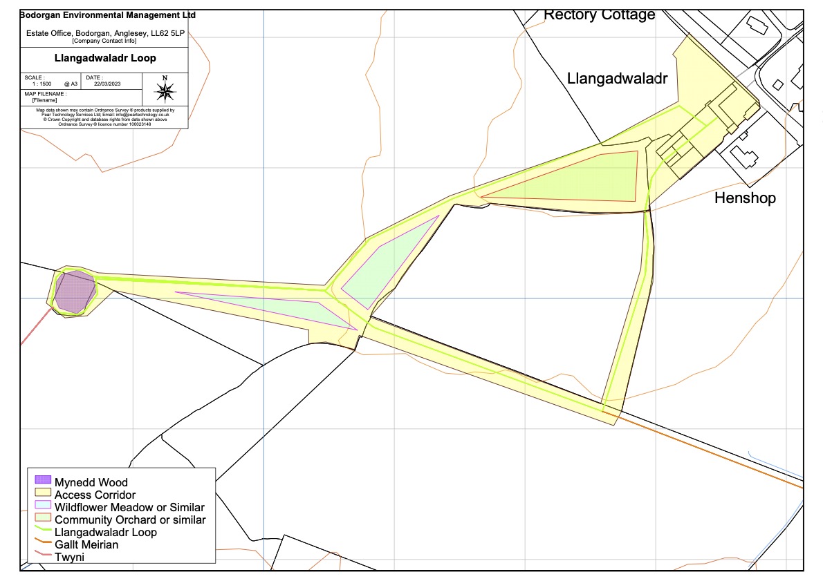
We are creating 2 new longer sections that join up with this short circular Llangadwaladr path to cater for the longer distance walker.
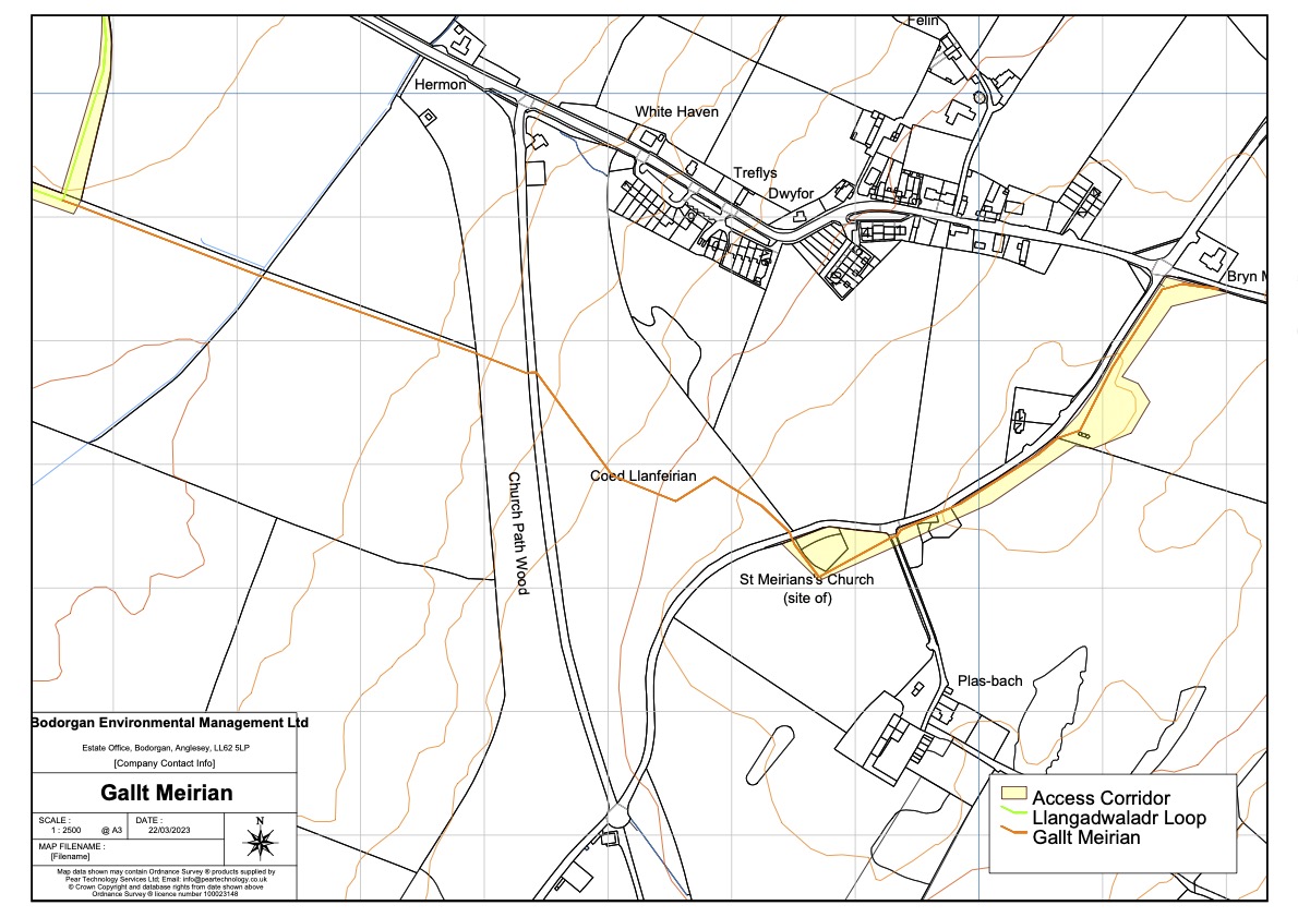
New footpath section 2: Longer distance route to and from Malltraeth (‘Meirian’)
This sections runs from Llangadwaldr to Malltraeth.
The route will cross the Afon Frechwen and cross a wooded slope before arriving at the site of St Meirian’s Church. The route will then proceed to the Second World War era look-out at Pen Boncan – which offers dramatic views to Snowdonia, Ynys Llanddwyn and Pen Lleyn – before joining Aberhoccwn Lane which leads to Malltraeth.
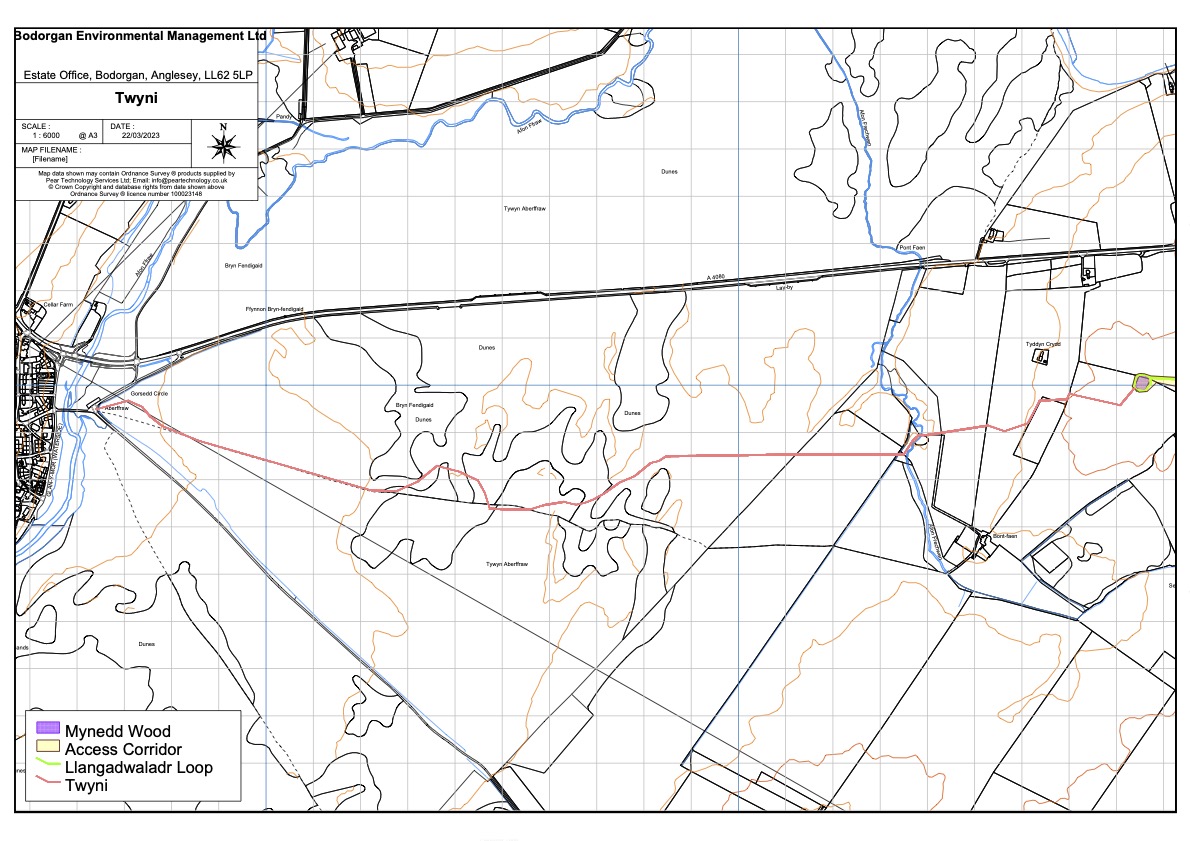
New footpath section 3: Longer distance route to and from Aberffraw (‘Twyni’)
This section runs from Llangadwaldr to Aberffraw.
The route will cross the Afon Frechwen and continue to the old bridge at Aberffraw through the dramatic sand dune system of Tywyn Aberffraw.
What features will we find along the way?
We have designed the routes of our new footpaths around particular features in the landscape:
- Second World War military infrastructure in the form of a surviving look-out tower and a resurrected grass runway;
- 2 ancient churches;
- Natural viewing points on higher land enjoying sublime views;
- River crossing points;
- Mature mixed/native woodland, a rare habitat on Anglesey; and
- What we think are the best sand dunes in Wales.
What is the thinking underpinning the design of the new footpaths?
We want to deliver new, high quality walking experiences that we hope will be well used.
The quality of experience that we want to deliver is as follows:
- Landscape and visual experience: to be both high quality and diverse.
- The walking surface: to be dry, level and easy to traverse.
- Physical context: the routes will pass by and reveal a number of historic and natural features.
- Historical context: we want the routes to tell the story of landscape change and the people who lived in this landscape.
What is the thinking underpinning the design of the new landform?
The new landform has been conceived to assist in the enjoyment and interpretation of and navigation through the landscape. The landform leads the walker to it and allows the walker to see where s/he is going.
The purpose of the landform is:
- To provide a focal point for the new sections of footpath;
- To raise walkers to an enhanced height so as to provide a viewing point for the stunning views Anglesey has to offer; and
- To offer a place of quiet contemplation, surrounded and assisted by nature.
Man-made landforms are not new to this landscape. Recently we discovered that there was once an ancient landform located very close to our proposed landform. However, the neolithic round barrow has now disappeared.
We are thinking about what to call the new landform. We like ‘Boncan Bodorgan’ or ‘Y Bonc’.
How has the Project gone about the task of route and landform design?
We have refined the proposals over time using local knowledge, memory and experience; archival material; discovery of historical objects hidden in the landscape; and keeping an open mind.
How has the Project conducted historical research?
1) interview local residents with memory of the 1940s and ‘50s so that we could explore local oral history and capture that memory; and
2) research the Bodorgan Estate archive so as to tell the tale of the Llanfeirian Experimental Farm.
The benefits the Project will bring for local people
- New and high quality access opportunities
- Opportunities for local people to walk a circuit from their front door
- Opportunities for health benefits associated with active lifestyles
- Opportunities for schools to access the historic landscape to bring the National Curriculum to life
- A new way of seeing a familiar landscape
- The sharing of local history and memory
The benefits the Project will bring for walkers
- New access to areas of high landscape value
- Connectivity to existing public rights of way giving the walker a wider variety of walk options
- A new landform which will provide a focal point for walks with fantastic views over south-west Anglesey
- Innovative interpretation around the walks which will provide insight into the history of the landscape and the people of this part of Anglesey
Will the footpath be accessible?
We will be offering a gentle, family friendly, circular route which will be free from obstruction as well as more adventurous walks over varying terrains.
Is there any charge to access the paths and landform?
Will car parking be available?
Are dogs welcome?
Do I need a map?
The 2 longer distance sections of footpath will be waymarked and / or sign posted and will not require a map to navigate.
We will be planting hedges and fencing in some areas to guide walkers, so it should be easy to follow our routes.
What footwear / kit do I need to bring with me?
For the easy circular walk at Llangadwaladr, trainers and everyday shoes will suit.
If you are intending to walk the longer distance routes, we would recommend walking boots or wellington boots in wetter periods.
Of course, you will need the usual supplies: water, a coat, suncream, a camera and a snack to enjoy on top of the landform.
What learning materials will be available?
We are planning on providing additional information along the routes.
When will the new paths be ready for walking?
The footpaths were officially opened to the public on August 25th 2024.
Will there be further improvements in the future?
How do we contact you?
Please contact us through this website.
Sustainable Management Scheme
Project Partners

Cyllidwyd y prosiect hwn drwy Cymunedau Gwledig Llywodraeth Cymru - Rhaglen Datblygu Gwledig Cymru 2014-2020, a ariennir gan Lywodraeth Cymru a’r Gronfa Amaethyddol Ewrop ar gyfer Datblygu Gwledig.
https://agriculture.ec.europa.eu/common-agricultural-policy/rural-development_en


Contact Details
Bodorgan
Anglesey
LL62 5LP
Local Partnerships:


© 2026 Bodorgan Estate - All Rights Reserved